Know the geography
Postal ZIP codes serve mail delivery. Census ZIP Code Tabulation Areas (ZCTAs) approximate those areas for statistics. Neither automatically matches a neighborhood, school district, or political boundary.
Census geography guide ↗SOCIOLOGY THROUGH THE LENS OF PLACE
Your ZIP code is more than an address. It is a starting point for understanding the conditions, connections, and opportunities that shape community life.
Explore the power of place ↗Place influences possibility.
People are always more than a statistic.
THE IDEA AT THE HEART OF THIS GUIDE01 / LOOK BENEATH THE ADDRESS
Explore community life through two related groups of six lenses. Start with economy and opportunity, then look at community and connections. Choose a lens for questions, measures, and practical next steps.
How places support commerce, visitors, work, housing, learning, and economic access.
How faith, heritage, relationships, health, environment, and civic life shape shared experience.
REAL WORK. REAL QUESTIONS.
National Data System’s ZIP code work connects place with air quality, economic conditions, relationships, heritage, and community life. Explore the project directory and examples drawn from that work.
AirQualityByZIP · Know Your ZIP Story · LoveByZIP · Most Wealthy ZIPs · Black Wealth Intelligence · RootsByZIP
FEATURED ZIP STORY / CULTURE & PLACE
How Beverly Hills, 90210 turned a famous setting into a conversation about adolescence, belonging, status, and the pressures behind privilege.
Read the 90210 story ↗
02 / SAME CITY. DIFFERENT DAILY LIFE.
Imagine two households with similar goals in communities with different resources. Use the lenses below to explore the conditions around them.

03 / THE POWER COMES WITH RESPONSIBILITY

Postal ZIP codes serve mail delivery. Census ZIP Code Tabulation Areas (ZCTAs) approximate those areas for statistics. Neither automatically matches a neighborhood, school district, or political boundary.
Census geography guide ↗Two measures moving together does not establish why. History, policy, selection, and overlapping conditions may explain an association. A ZIP-level comparison alone cannot identify a causal effect.
Survey estimates have margins of error. Align time periods, populations, and definitions before comparing places. Apparent differences may be too uncertain to support a conclusion.
Understanding Census estimates ↗An area’s average income, education, or household structure does not describe every resident. This is the ecological fallacy: mistaking a group pattern for an individual fact.
Resident voices can reveal mutual aid, cultural knowledge, informal caregiving, and leadership that datasets miss. Listen to communities when interpreting their conditions.
Use evidence to improve access, invest in overlooked communities, and evaluate change. Protect privacy and challenge interpretations that stigmatize a place or its residents.
A RESEARCH WINDOW

The Opportunity Atlas connects childhood locations with later adult outcomes. Its neighborhood mobility data use census tracts, rather than ZIP codes. It offers a deeper scale for investigating opportunity within a broader area.
For ZIP-level storytelling, this distinction matters: a broad area may contain very different local experiences. Use finer geography when the question requires it.
Explore the Census research ↗04 / FROM KNOWING TO DOING
Choose your perspective for a practical conversation starter. Bring these questions to a community meeting, planning session, or reporting assignment.

ABOUT US / THE AUTHOR & THE PURPOSE
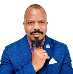

Christopher C. Herring is the author of this site. His work brings sociology, organizational leadership, and geographic intelligence together to explore how people live, connect, work, and experience opportunity.
He attended Boston University and graduated with a bachelor’s degree in Sociology. He earned a master’s degree in Administrative Sciences and Organizational Management from the George Washington University and a Master of Science in Human Resources Management from Chapman University.
Herring has deepened his study of people through his service as a retired commissioned officer, his work in international business leading chambers of commerce, and his development of a global spatial intelligence system.
His work studies people and geography through datasets and brings those insights into public awareness through Consumer Magazine. The Power of the ZIP Code invites you to connect evidence with everyday experience—and to ask better questions about the communities around us.
Explore the ZIP code stories behind the work ↗WHY THIS SITE EXISTS
To help people understand what place-based evidence can reveal about community life, connect that evidence with lived experience, and turn awareness into better decisions.
QUESTIONS WORTH ASKING
No. It describes an area or service geography, not an individual’s character, beliefs, abilities, or future. People vary widely within every place.
No. Local conditions can expand or constrain opportunities, but individual experiences also reflect family, institutions, relationships, policies, and choices. An address is context, not a prediction.
A single ranking can hide tradeoffs and stigmatize places. Define the question first, show the measures and uncertainty, and include community strengths alongside unmet needs.
This field guide connects to real National Data System projects through the ZIP story directory90210 story, including air-quality history and a documented 78209 economic profile. The two-community teaching comparison is fictional. Live lookups and each project’s methods belong to the linked destinations.